Transportation
On This Page
- PDX Reporter
- Crosswalks Needed
- SW Capitol Highway Project
- I-5 SW Portland Bridge and Ramp Improvements
- Barbur Crossroads Safety Project Update
- West Portland Town Center
- Southwest Corridor Project
- Tryon-Stephens Headwaters Neighborhood Street Plan
- PBOT’s Slow Streets Program
PDX Reporter
PDXReporter
PDX Reporter is the official app for Portlanders to report livability concerns to the city. When you see a sidewalk trip hazard, an abandoned car, or a clogged storm drain you can take a photo and upload it to the app which will automatically send your report to the relevant city bureau
Crosswalks Needed
We’ve been asked by the City of Portland to identify areas where painted crosswalks are needed. These recommendations are not prioritized at all, since SW trails will run them through their algorithm and will be ranked with the other SW neighborhood requests.
Hopefully some of ours will make the top 20 list that will get sent off to PBOT.
Click here for a map of the locations identified so far.
Click here for a spreadsheet listing crosswalk recommendations
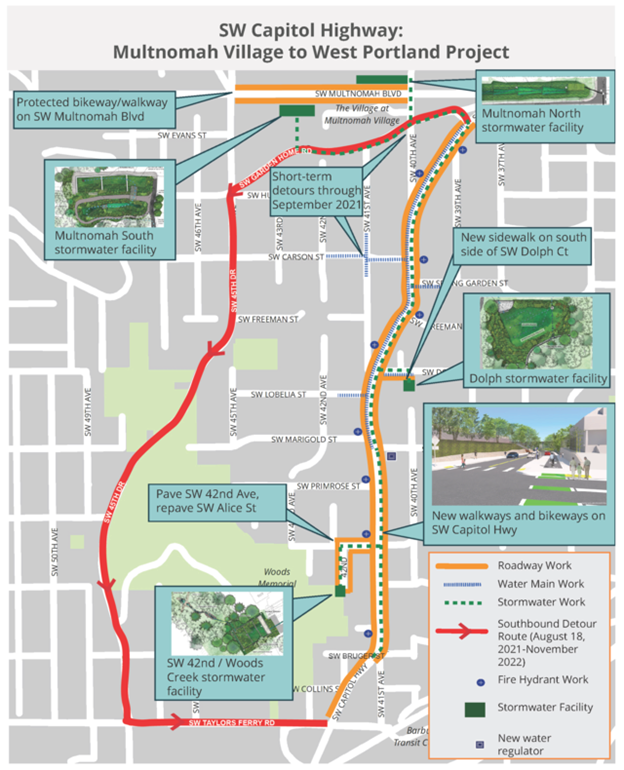
SW Capitol Highway: Multnomah Village — West Portland Project
SW Capitol Highway Subcomittee Meeting June 1
Time: Jun 1, 2022 7:00 to 8:30 PM Pacific Time (US and Canada)
Thanks to all who joined the meeting last night for the latest updates on the project and to share feedback with city staff. For those who weren’t able to attend, PBOT’s powerpoint presentation is a wealth of information and can be viewed.
Click here for the link
Thanks,
Chris Lyons
SW Capitol Highway Subcommittee
Multnomah Neighborhood Association
Click here for What’s Happening Now
The City of Portland’s contractor Landis & Landis Construction (LLC) began major construction work on June 14 along SW Capitol Highway.
The detour of southbound traffic on SW Capitol Highway between SW Garden Home Road and SW Taylors Ferry Road began Wednesday morning, August 18, 2021, and will be in effect until as late as November 2022. The detour is necessary as part of the Portland Bureau of Transportation’s SW Capitol Highway: Multnomah Village – West Portland project in partnership with the Bureau of Environmental Services and Water Bureau.
For more information visit the Project Website
Frequently Asked Questions
Residents and travelers through the area have had some questions that are shared in a new SW Capitol Highway Detour Frequently-Asked Questions (FAQ) article.
Click here for the FAQ.
Older MNA comments
SW Capitol Highway Subcommittee Cross Section Comments 12-13-16
MNA Capitol Highway Letter to Legislators.pdf
MNA Capitol Highway Letter to City of Portland.pdf
I-5 SW Portland Bridge and Ramp Improvements
Oregon Department of Transportation (ODOT) is currently designing projects to improve the I-5 bridge at SW 26th Avenue and repair three ramps that access I-5 in SW Portland. These structural improvements will maintain and extend the life of our roadway system and give travelers a smoother ride.
ODOT is always listening to and considering feedback from community and we look forward to future engagement opportunities with you. Contact Hope with comments and questions at hope.estes@odot.state.or.us or
View the project website here
Schedule
Construction of the ramp repairs (including resurfacing, protective paint, new railings and more) is starting summer 2021 and may take up to one year to complete.
SW Barbur Blvd on-ramp to I-5 north:
- Nighttime single lane closures.
- Remove old paint and repaint steel bridge structure.
- Replace bolts as needed.
Barbur Crossroads Safety Project
Pre-Construction Update
About
The Oregon Department of Transportation (ODOT) will be making safety improvements to the Barbur Crossroads area where SW Barbur Blvd, SW Capitol Hwy and SW Taylors Ferry Rd meet. The project includes many safety elements including a new wider sidewalk, ADA ramps, pedestrian countdown signals, new illumination, new bicycle markings, as well as a slight change to traffic operations to reduce vehicle crashes. The top priority of this project is to improve safety.
Project Elements
- New accessible curb ramps in the project area.
- New sidewalk on east side of Capitol Highway.
- Prohibited left turn from northbound Capitol Highway to southbound Barbur Blvd. and the I-5 south on-ramp.
- Right turn only lane from Taylors Ferry Road onto Barbur Blvd.
- Bike box and green conflict markings on Barbur Blvd. at Taylors Ferry crossing, Capitol Highway crossing and Barbur TC driveway.
- Audible pedestrian signals.
- New wayfinding signs around project area to help direct travelers to I-5, Barbur Blvd., PCC and Barbur Transit Center.
- Sign replacement at I-5 south on-ramp
West Portland Town Center
The West Portland Town Center Plan draft is now at Portland Planning & Sustainability Commission (PSC). Next meeting Nov, 30, 5 PM- Work Session with possible recommendations.
For more information on WPTC, click here for our Land Use page
Southwest Corridor Project
Even though the Southwest Corridor Light Rail Project funding failed, other parts of the Southwest Corridor Plan and West Portland Town Center Plan continue, such as multifamily housing, equitable development, and other infrastructure projects which affect Multnomah Neighborhood
Tryon-Stephens Headwaters Neighborhood Street Plan
The Portland Bureau of Transportation (PBOT) and the Bureau of Environmental Services (BES) are working together on the Tryon-Stephens Headwaters Neighborhood Street Plan (PDF). The objective of the street plan is to establish a more connected local street and pathway network and to improve stormwater management systems within the area. Recommendations made in this plan will reflect community priorities and suggestions to achieve our transportation and stormwater goals.
More at http://www.portlandoregon.gov/transportation/65574
PBOT’s Slow Streets program moves ahead with permanent installations in response to positive community support
The familiar green signs and orange temporary traffic barrels are evolving to concrete planters and shared street signage to better maintain calm streets and slow traffic on many of Portland’s neighborhood greenways
(July 29, 2021) The Portland Bureau of Transportation’s Slow Streets program is growing up. Following the overwhelmingly positive public response to the program, the bureau is now transitioning locations around the city from temporary traffic barrels and signage to more permanent infrastructure to alert drivers and other travelers that they are entering a neighborhood greenway and should expect to share the space with people biking, walking, rolling and strolling.

PBOT’s Slow Streets program is a component of the Safe Streets Initiative, the bureau’s response to the Covid-19 pandemic. In May of 2020, PBOT converted 100 miles of low-traffic streets and neighborhood greenways into Slow Streets to restrict cut-through traffic and create space for Portlanders to walk, bike, roll, and stroll safely during the public health crisis.
Learn more about PBOT’s Slow Streets program at https://www.portland.gov/transportation/safestreetspdx/what-slow-streets-program.